


Lac des escarcets Plaine des Maures

lygi
User
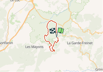

Length
18.7 km

Max alt
453 m

Uphill gradient
534 m
Km-Effort
26 km

Min alt
69 m

Downhill gradient
532 m
Boucle
Yes
Creation date :
2019-03-27 09:20:35.379
Updated on :
2019-03-27 09:26:11.875
5h27
Difficulty : Very difficult

FREE GPS app for hiking
 SityTrail
IGN / Geographical institutes
SityTrail Plus
The world is yours!
About
Trail Walking of 18.7 km to be discovered at Provence-Alpes-Côte d'Azur, Var, Le Cannet-des-Maures. This trail is proposed by lygi.
Description
a faire au mois de mars pour toute la flore
Positioning
Country:
France
Region :
Provence-Alpes-Côte d'Azur
Department/Province :
Var
Municipality :
Le Cannet-des-Maures
Location:
Unknown
Start:(Dec)
Start:(UTM)
290271 ; 4800731 (32T) N.
Comments